|
|
| |
|
 |
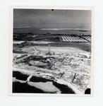
| Aerial view of Government Road and salt ponds taken December 19th, 1945 |
|
| Publication Date: | |
1945
|
| Creator: | |
Monroe County Public Library System
May Hill Russell Library -- History Dept
Ida Woodward Barron Collection
|
| Format: | |
1 photograph : b&w ; 7 x 7 in.
|
| Subjects.Display: | |
Photographs -- Key West (Fla.)
Monroe -- 12087
Aerial photographs -- Monroe County (Fla.)
Airports -- Aerial photographs -- Florida -- Key West
Bunkers (Fortification) -- Aerial Photographs -- Florida -- Key West
Roads -- Aerial photographs -- Florida -- Key West
Bridges -- Aerial photographs -- Florida -- Key West
Railroad bridges -- Aerial photographs -- Key West (Fla.)
|
| Source Institution: | |
Florida International University
|
|
| Aerial view of Government Road and salt ponds taken December 19th, 1945 |
|
 |
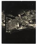
| An aerial view of Key West from White Street to the Airport |
|
| Publication Date: | |
1960/1969
|
| Creator: | |
Monroe County Public Library System
May Hill Russell Library -- History Dept
|
| Format: | |
1 photograph : b&w ; 8 x 10 in.
|
| Subjects.Display: | |
Monroe -- 12087
Aerial photographs -- Monroe County (Fla.)
Aerial photographs -- Key West (Fla.)
Airports -- Aerial photographs -- Florida -- Key West
Roads -- Aerial photographs -- Florida -- Key West
|
| Source Institution: | |
Florida International University
|
| Donor: | |
Westray, Bill
|
|
| An aerial view of Key West from White Street to the Airport |
|
|
 |
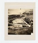
| Aerial view of the airport at Key West's eastern end |
|
| Publication Date: | |
1942
|
| Creator: | |
Monroe County Public Library System
May Hill Russell Library -- History Dept
Ida Woodward Barron Collection
|
| Format: | |
1 photograph : b&w ; 8 x 10 in.
|
| Subjects.Display: | |
Aerial photographs -- Monroe County (Fla.)
Buildings, structures, etc -- Aerial photographs -- Key West (Fla.)
Aerial photographs -- Key West (Fla.)
Airports -- Aerial photographs -- Florida -- Key West
Runways (Aeronautics) -- Aerial photographs -- Florida -- Key West
|
| Source Institution: | |
Florida International University
|
|
| Aerial view of the airport at Key West's eastern end |
|
 |
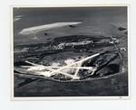
| Airport and eastern end of Key West looking north to Sigsbee |
|
| Publication Date: | |
1943
|
| Creator: | |
Monroe County Public Library System
May Hill Russell Library -- History Dept
Ida Woodward Barron Collection
|
| Format: | |
1 photograph : b&w ; 8 x 10 in.
|
| Subjects.Display: | |
Monroe -- 12087
Aerial photographs -- Monroe County (Fla.)
Buildings, structures, etc -- Aerial photographs -- Key West (Fla.)
Aerial photographs -- Key West (Fla.)
Airports -- Aerial photographs -- Florida -- Key West
Parks -- Aerial photographs -- Florida -- Key West
|
| Source Institution: | |
Florida International University
|
|
| Airport and eastern end of Key West looking north to Sigsbee |
|
|
 |
| East Martello and Meacham Field Key West |
|
| Publication Date: | |
1928
|
| Creator: | |
Monroe County Public Library System
May Hill Russell Library -- History Dept
Warren Family Collection
|
| Format: | |
1 photograph : b&w ; 8 x 10 in.
|
| Subjects.Display: | |
Monroe -- 12087
Aerial photographs -- Monroe County (Fla.)
Aerial photographs -- Key West (Fla.)
Airports -- Aerial photographs -- Florida -- Key West
Martello towers -- Aerial photographs -- Florida -- Key West
|
| Source Institution: | |
Florida International University
|
|
| East Martello and Meacham Field Key West |
|
|
|

